


<< Our Photo Pages >> Morfa Stone - Standing Stone (Menhir) in Wales in Gwynedd
Submitted by TAlanJones on Tuesday, 30 April 2024 Page Views: 22
Neolithic and Bronze AgeSite Name: Morfa StoneCountry: Wales County: Gwynedd Type: Standing Stone (Menhir)
Nearest Town: Llwyngwril Nearest Village: Friog
Map Ref: SH6144811077
Latitude: 52.679623N Longitude: 4.050893W
Condition:
| 5 | Perfect |
| 4 | Almost Perfect |
| 3 | Reasonable but with some damage |
| 2 | Ruined but still recognisable as an ancient site |
| 1 | Pretty much destroyed, possibly visible as crop marks |
| 0 | No data. |
| -1 | Completely destroyed |
| 5 | Superb |
| 4 | Good |
| 3 | Ordinary |
| 2 | Not Good |
| 1 | Awful |
| 0 | No data. |
| 5 | Can be driven to, probably with disabled access |
| 4 | Short walk on a footpath |
| 3 | Requiring a bit more of a walk |
| 2 | A long walk |
| 1 | In the middle of nowhere, a nightmare to find |
| 0 | No data. |
| 5 | co-ordinates taken by GPS or official recorded co-ordinates |
| 4 | co-ordinates scaled from a detailed map |
| 3 | co-ordinates scaled from a bad map |
| 2 | co-ordinates of the nearest village |
| 1 | co-ordinates of the nearest town |
| 0 | no data |
Internal Links:
External Links:
")
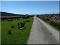
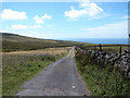
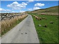
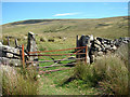
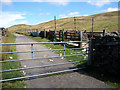
Situated in a field to the south of a narrow gated country lane that leads from Llwyngwril to Dolgellau the stone stands close a dry stone boundary wall. Interestingly, there's an alignment of standing stones about 100m to the NE and this upland expanse has evidence of prehistoric activity in abundance.
The stone stands at about 0.75m, with a base measurement of 1.30m and a thickness of about 0.40m giving it a domed/barrow shape. It leans to the east and there is some packing on its eastern side. This is a smooth polished stone, with some lichen, that has been loved by the local sheep. However, it is earth fast and stable, I sat on it and pushed against the wall.
An interesting stone feature that just happens to share an environment that has attracted the attention of our ancestors for millenia.
You may be viewing yesterday's version of this page. To see the most up to date information please register for a free account.
")
")
")
Do not use the above information on other web sites or publications without permission of the contributor.
Nearby Images from Geograph Britain and Ireland:
©2019(licence)
©2020(licence)
©2019(licence)
©2006(licence)
©2006(licence)
The above images may not be of the site on this page, they are loaded from Geograph.
Please Submit an Image of this site or go out and take one for us!
Click here to see more info for this site
Nearby sites
Key: Red: member's photo, Blue: 3rd party photo, Yellow: other image, Green: no photo - please go there and take one, Grey: site destroyed
Download sites to:
KML (Google Earth)
GPX (GPS waypoints)
CSV (Garmin/Navman)
CSV (Excel)
To unlock full downloads you need to sign up as a Contributory Member. Otherwise downloads are limited to 50 sites.
Turn off the page maps and other distractions
Nearby sites listing. In the following links * = Image available
327m N 7° Hut Enclosure and Early Field System South of Mynydd Graigwen* Ancient Village or Settlement (SH615114)
355m NE 53° Waun Oer* Stone Row / Alignment (SH61741128)
525m N 4° Gallt Ffynnon Yr Hydd Enclosure* Ancient Village or Settlement (SH615116)
914m NE 53° Cairn West of Bryn Seward* Cairn (SH622116)
1.1km NE 50° Bryn Seward Probable Cairn* Cairn (SH6231011750)
1.1km WSW 237° Cefnfeusydd Farm Cairns* Cairn (SH605105)
1.1km NE 48° Bryn Seward Settlement* Ancient Village or Settlement (SH623118)
1.1km NE 50° Bryn Seward Cairn Cemetery* Barrow Cemetery (SH6233011770)
1.1km ENE 60° Bryn Seward Cairn 3* Cairn (SH6244811614)
1.1km NE 56° Bryn Seward Cairn 4* Cairn (SH6240711687)
1.2km ENE 67° Bryn Seward Round House and Field System* Ancient Village or Settlement (SH6254111493)
1.2km ENE 57° Bryn Seward Cairn 6* Cairn (SH6247211700)
1.2km NE 55° Bryn Seward Cairn 5* Cairn (SH6245911744)
1.2km ENE 57° Bryn Seward Cairn 7* Cairn (SH6249011722)
1.2km NE 54° Bryn Seward Cairn 2* Cairn (SH6246011770)
1.3km ENE 60° Bryn Seward Hut Circle* Ancient Village or Settlement (SH6256411688)
1.3km ENE 59° Bryn Seward Cairn 1* Cairn (SH6259711729)
1.3km ENE 57° Bryn Seward Stone Row* Stone Row / Alignment (SH6258811760)
1.4km NE 56° Bryn Seward Cairn East* Cairn (SH626118)
1.4km E 87° Pen y Garn Cairn and Cist* Cairn (SH6284911112)
1.6km WSW 238° Gwastadgoed* Standing Stones (SH601103)
1.8km ENE 71° Hut Circle Settlement SE of Cyfannedd Fawr* Ancient Village or Settlement (SH6313011590)
1.8km ENE 73° Cyfannedd Fawr erratic* Natural Stone / Erratic / Other Natural Feature (SH63221155)
2.0km ENE 69° Settlement and Cairn South of Cyfannedd Fawr* Ancient Village or Settlement (SH6331011730)
2.0km ENE 77° Bedd-y-brenin* Cairn (SH6343811484)
View more nearby sites and additional images


 We would like to know more about this location. Please feel free to add a brief description and any relevant information in your own language.
 Wir möchten mehr über diese Stätte erfahren. Bitte zögern Sie nicht, eine kurze Beschreibung und relevante Informationen in Deutsch hinzuzufügen.
 Nous aimerions en savoir encore un peu sur les lieux. S'il vous plaît n'hesitez pas à ajouter une courte description et tous les renseignements pertinents dans votre propre langue.
 Quisieramos informarnos un poco más de las lugares. No dude en añadir una breve descripción y otros datos relevantes en su propio idioma.