


<< Our Photo Pages >> Bryn Seward Cairn 3 - Cairn in Wales in Gwynedd
Submitted by TAlanJones on Monday, 29 April 2024 Page Views: 15
Neolithic and Bronze AgeSite Name: Bryn Seward Cairn 3Country: Wales County: Gwynedd Type: Cairn
Nearest Town: Llwyngwril Nearest Village: Friog
Map Ref: SH6244811614
Latitude: 52.684703N Longitude: 4.036336W
Condition:
| 5 | Perfect |
| 4 | Almost Perfect |
| 3 | Reasonable but with some damage |
| 2 | Ruined but still recognisable as an ancient site |
| 1 | Pretty much destroyed, possibly visible as crop marks |
| 0 | No data. |
| -1 | Completely destroyed |
| 5 | Superb |
| 4 | Good |
| 3 | Ordinary |
| 2 | Not Good |
| 1 | Awful |
| 0 | No data. |
| 5 | Can be driven to, probably with disabled access |
| 4 | Short walk on a footpath |
| 3 | Requiring a bit more of a walk |
| 2 | A long walk |
| 1 | In the middle of nowhere, a nightmare to find |
| 0 | No data. |
| 5 | co-ordinates taken by GPS or official recorded co-ordinates |
| 4 | co-ordinates scaled from a detailed map |
| 3 | co-ordinates scaled from a bad map |
| 2 | co-ordinates of the nearest village |
| 1 | co-ordinates of the nearest town |
| 0 | no data |
Internal Links:
External Links:
")
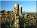
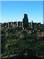
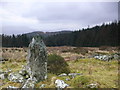
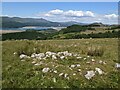
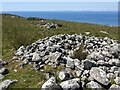
Situated in the uplands above Friog the site can be reached by car along the narrow gated road that leads from Llwyngwril to Dolgellau. Coflein has identified this cairn as prehistoric NPRN 500765. The cairn lies about 100m south of the road within an area that has several cairns and stone piles. However, this cairn lies at the edge of the cairn field making it a little easier to identify.
This is a small cairn that's defined by a ring of earth fast stones in an area that's otherwise stone free. It has a 3m diameter with a slight earth mound of about 0.3m within the ring of stones.
This area attracts a lot of visitors due to its scenery and serenity.
You may be viewing yesterday's version of this page. To see the most up to date information please register for a free account.
")
")
")
Do not use the above information on other web sites or publications without permission of the contributor.
Nearby Images from Geograph Britain and Ireland:
©2007(licence)
©2007(licence)
©2014(licence)
©2023(licence)
©2023(licence)
The above images may not be of the site on this page, they are loaded from Geograph.
Please Submit an Image of this site or go out and take one for us!
Click here to see more info for this site
Nearby sites
Key: Red: member's photo, Blue: 3rd party photo, Yellow: other image, Green: no photo - please go there and take one, Grey: site destroyed
Download sites to:
KML (Google Earth)
GPX (GPS waypoints)
CSV (Garmin/Navman)
CSV (Excel)
To unlock full downloads you need to sign up as a Contributory Member. Otherwise downloads are limited to 50 sites.
Turn off the page maps and other distractions
Nearby sites listing. In the following links * = Image available
84m NNW 329° Bryn Seward Cairn 4* Cairn (SH6240711687)
89m NNE 14° Bryn Seward Cairn 6* Cairn (SH6247211700)
116m NNE 20° Bryn Seward Cairn 7* Cairn (SH6249011722)
130m N 3° Bryn Seward Cairn 5* Cairn (SH6245911744)
137m NE 56° Bryn Seward Hut Circle* Ancient Village or Settlement (SH6256411688)
152m SE 141° Bryn Seward Round House and Field System* Ancient Village or Settlement (SH6254111493)
156m N 3° Bryn Seward Cairn 2* Cairn (SH6246011770)
188m NE 51° Bryn Seward Cairn 1* Cairn (SH6259711729)
193m NW 313° Bryn Seward Probable Cairn* Cairn (SH6231011750)
195m NW 321° Bryn Seward Cairn Cemetery* Barrow Cemetery (SH6233011770)
202m NE 42° Bryn Seward Stone Row* Stone Row / Alignment (SH6258811760)
237m NW 320° Bryn Seward Settlement* Ancient Village or Settlement (SH623118)
240m NE 38° Bryn Seward Cairn East* Cairn (SH626118)
248m W 265° Cairn West of Bryn Seward* Cairn (SH622116)
641m SE 140° Pen y Garn Cairn and Cist* Cairn (SH6284911112)
680m E 90° Hut Circle Settlement SE of Cyfannedd Fawr* Ancient Village or Settlement (SH6313011590)
772m E 93° Cyfannedd Fawr erratic* Natural Stone / Erratic / Other Natural Feature (SH63221155)
781m WSW 243° Waun Oer* Stone Row / Alignment (SH61741128)
867m E 81° Settlement and Cairn South of Cyfannedd Fawr* Ancient Village or Settlement (SH6331011730)
945m W 268° Gallt Ffynnon Yr Hydd Enclosure* Ancient Village or Settlement (SH615116)
969m WSW 256° Hut Enclosure and Early Field System South of Mynydd Graigwen* Ancient Village or Settlement (SH615114)
995m E 96° Bedd-y-brenin* Cairn (SH6343811484)
1.1km WSW 240° Morfa Stone* Standing Stone (Menhir) (SH6144811077)
1.2km NE 55° Cyfannedd Fawr Settlement* Ancient Village or Settlement (SH6342012260)
1.2km ENE 63° Braich Ddu Cairns* Cairn (SH6350512120)
View more nearby sites and additional images


 We would like to know more about this location. Please feel free to add a brief description and any relevant information in your own language.
 Wir möchten mehr über diese Stätte erfahren. Bitte zögern Sie nicht, eine kurze Beschreibung und relevante Informationen in Deutsch hinzuzufügen.
 Nous aimerions en savoir encore un peu sur les lieux. S'il vous plaît n'hesitez pas à ajouter une courte description et tous les renseignements pertinents dans votre propre langue.
 Quisieramos informarnos un poco más de las lugares. No dude en añadir una breve descripción y otros datos relevantes en su propio idioma.